|
|
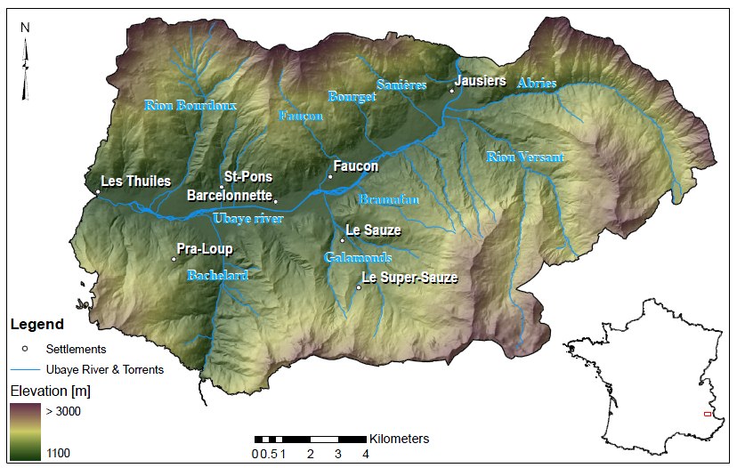
French Alps, Ubaye and Tinée valleys.
| |
The study site is located in the Barcelonnette basin which lies in the Southern French Alps in the D�epartement Alpes des Haute Provence. The considered zone encompasses almost the complete area of the municipalities Jausiers, Faucon de Barcelonnette, Saint-Pons, Uvernet-Fours, Enchastrayes and Barcelonnette.
The population of these six municipalities amounts to nearly 6,000 inhabitants. However, due to summer and winter tourism the number of people residing in the area is temporarily much higher as the large number of beds available in hotels and capacities in camping places indicate.
The valley extends between an altitude of 1,100 and 3,100 m a.s.l. and is drained by the Ubaye river in which a large number of torrents flow. It is characterised by (a) a mountain climate with pronounced interannual rainfall variability (735 � 400 mm) and 130 freezing days per year, (b) a continental in sequence with large intra-day thermal amplitudes (>20o) and multiple freeze-thaw cycles and (c) a Mediterranean influence with summer rainstorms providing occasionally more than 50 mm/h. These summer rainstorms, as well as heavy rains on melting snow accumulations in spring, lead to high discharges.
Meso-climatic di�fferences emerge due to the orientation of the valley in an east-west direction, especially between the north- and south-facing slopes. Geologically, the valley presents a structural window with autochtonous Callovo-Oxfordian black marls (the Terres Noires) below the allochtonous Autapie and Parpaillon Flysch . As result of this geological setting, the upper slopes (1,900 - 3,000 m a.s.l.) consist of thrust sheets of cataclastic calcareous sandstones and are mostly steeper than 45o. A layer of non-consolidated weathered debris between 0.5 and 5 m thickness covers large parts of these slopes leading to debris tracks. The lower slopes (1,100 - 1,900 m.a.s.l.) are much gentler with angles of 10o to 30o and consist of the Callovo-Oxfordian black marls, fragile plates and flakes in a clayey matrix. These zones are mostly covered by Quaternary deposits such as poorly sorted debris at taluses, moraine deposits or landslide material. A multitude of debris cones from the torrents characterise the valley.
Due to their fertility and shallow slopes several of the cones are populated such as Sani�eres, Bourget, Faucon or Saint-Pons (Weber, 1994). Weathering and disintegration of sand- and limestones give rise to the formation of sandy and loamy regolith. On Flysch, sandy or loamy regolith may further develop to silty or clayey regolith. The vegetation mainly consists of forests and alpine pastures with a dominance of alpine pastures and bare rock outcrops above the tree line which is located at about 2400 m at south-facing and 2200 m at north-facing shadowy slopes. The forest cover had diminished in the 17th, 18th and 19th centuries drastically due to the use of wood and the extension of arable land |
| |
 |
| Presentation |
Presentation |
| Data sheets |
Data sheet |
| Stakeholder meetings |
Stakeholder meeting April 2012 |
| Data access |
The Barcelonnette area is part of the French Observatory on Landslides (OMIV)
Website: http://eost.u-strasbg.fr/omiv
|
|
|